


bierce
-
Posts
3269 -
Joined
-
Last visited
Content Type
Profiles
Texas Longhorns News
2025 Recruits
2024 Schedule
2026 Recruits
2025 Schedule
2027 Recruits
2026 Schedule
2028 Recruits
Gallery
Downloads
Forums
Blogs
Store
Everything posted by bierce
-
10 pm CDT NHC discussion (again a few minutes early) The hurricane has turned westward and slowed down slightly on the south side of a ridge centered over the southeastern U.S., with the latest initial motion estimated to be 275/14 kt. Beryl is expected to maintain that general motion during the next 12 hours, which should cause it to make landfall in the Yucatan Peninsula very near Tulum early Friday morning. Most of the models show the center remaining over land for about 18 hours, and then emerging over the southwestern Gulf of Mexico Friday night. Around that time, Beryl is expected to turn to the northwest and slow down some more as it moves along the western periphery of the weakening ridge and toward a trough over the south-central U.S. Although the models are in fair agreement, there is still some spread in exactly how sharp the system turns northwestward, and to a large degree the structure and intensity of Beryl will be a notable factor on its track over the Gulf. The new NHC track forecast is a little slower than the previous one, following the trend in the latest models. It now seems likely that Beryl will maintain its strength until it reaches the coast. Once the core moves inland, rapid weakening is expected, and Beryl is forecast to fall below hurricane strength by the time it exits the Yucatan. Assuming the system is able to maintain some elements of an inner core, gradual re-intensification seems likely before it makes its final landfall in northeastern Mexico or southern Texas. The NHC intensity forecast again lies near the high end of the models and continues to show Beryl becoming a hurricane again over the western Gulf. Users are reminded that the average NHC track error at day 3 is around 100 miles, so it is too soon to pinpoint where the largest impacts will be.
-
18z Jul 4 GFS model also has Beryl fizzling out over the Yucatan and never regaining much strength.
-
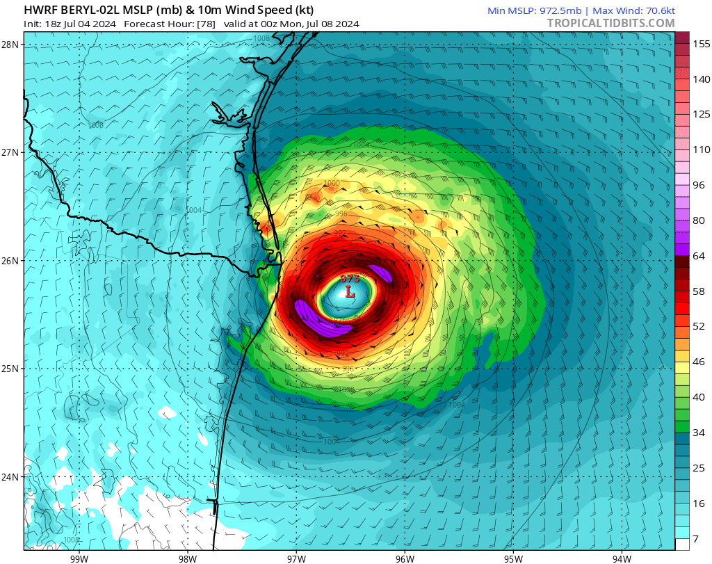
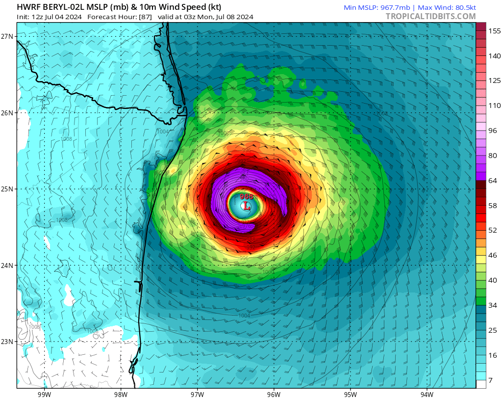
HWRF model finally ran to a point just south of the Texas/Mexico border. Image is projection for July 7, 7 pm. three hours after HMON had Beryl at a similar latitude. HWRF model is a bit weaker than it was from the model 6 hours ago, but still showing hurricane strength winds at this point, and it is still over water and intensifying.

-
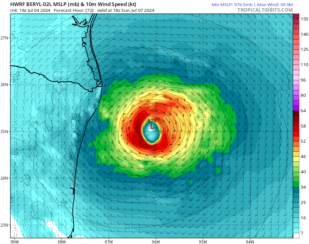
HWRF model has frozen at 1 pm on July 7, so I can't show the 4 pm projection. Here's the 1 pm projection. Still much stronger than HMON, but no longer showing Beryl taking 12-18 more hours to get to the Brownsville area.
-
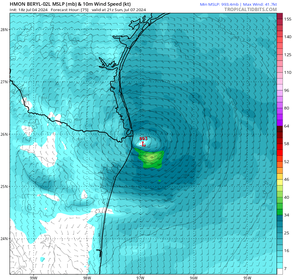
HMON run at 18z largely unchanged from 6 hours before. Instead of comparing it to HWRF at the same hour, I'll compare them as they pass Matamoros/Brownsville. HMON has it there at 4 pm on July 7. I'll put up the HWRF chart when it becomes available in about 10-15 minutes. Here's HMON projection for 4 pm on July 7.
-
Neither are Brownsville, Matamoros, or Houston, yet we discuss landfall in terms of those cities.
-
Today's 5 pm EDT discussion from NHC (so it came out a few minutes early) A large ridge centered over the southeastern U.S. should cause Beryl to move westward or west-northwestward during the next day or so, with the model guidance tightly clustered about a landfall on the Yucatan Peninsula in 12-18 h and emerging into the southwestern Gulf of Mexico at around 30 h. After that, Beryl should turn northwest toward a developing break in the subtropical ridge caused by a mid-latitude trough over the central United States. This general motion should continue until the cyclone makes landfall on the western Gulf coast between 72-96 h. There is still some spread in the track guidance regarding a landfall location, with the range of possibilities from northeastern Mexico to the middle Texas coast. Users are reminded that the average track forecast error at day 3 is about 100 miles and at day 4 is about 150 miles, and so it is still too early to pinpoint a specific region for the worst hazards. The new official forecast is a little north of the previous forecast through 24 h and similar to the previous forecast after that. It is unclear whether the current developments with the hurricane core and outflow are temporary or a sign that the westerly shear has somewhat abated. The intensity forecast follows the premise that the shear has not fully abated and that Beryl will weaken before landfall. However, even the intensity guidance that forecasts weakening keeps Beryl at hurricane strength at landfall on the Yucatan Peninsula. Additional weakening should occur while the center is over land. Over the Gulf of Mexico, the guidance does not forecast a lot of strengthening, but conditions appear generally favorable and the intensity forecast continues to show Beryl at hurricane strength before landfall on the western Gulf coast. It should be noted that the dynamical models suggest that the best chance for re-intensification could be during the last 12-18 hr before the western Gulf landfall, with the storm slow to intensify before that time.
-
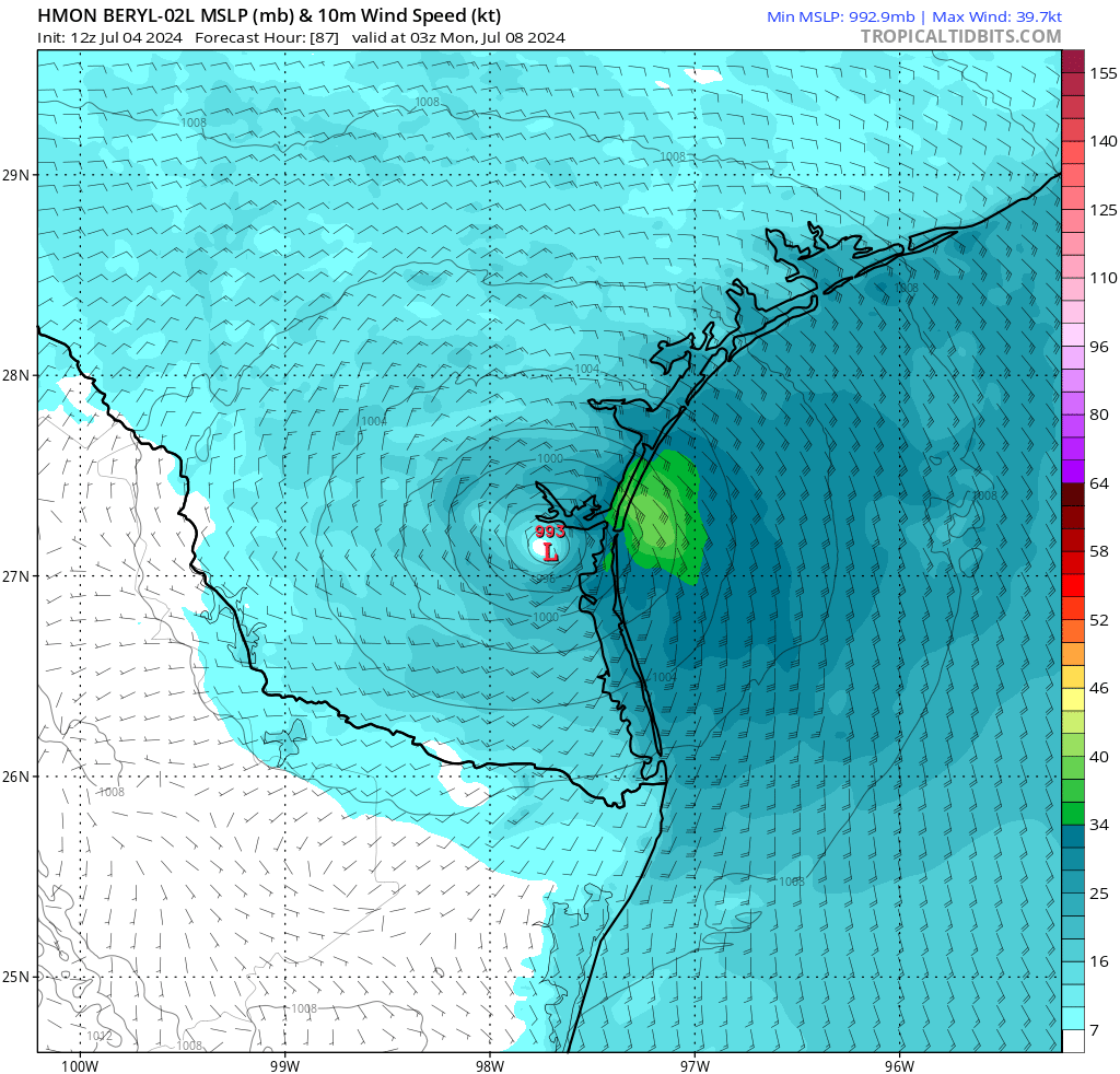
Here are the images from HMON and HWRF for July 7 10 pm CDT. Quite a disagreement.
-
Latest runs of HMON and HWRF strongly disagree on storm strength. Latest run to which I have access for full model is 12Z or 7 am CDT. I am getting model updates through tropicaltidbits.com, which has them about 5 hours after the fact. If anyone knows of a site that shows the full model run in detail earlier, please let me know. HMON now projects Beryl to make landfall in South Texas with windspeeds only around 40 mph due to near dissipation while crossing the Yucatan and little to no intensification during the gulf crossing until just before hitting the coast. HWRF looks to be projecting a much stronger system retaining a discernible eye coming out of the Yucatan, slower movement, more regeneration in the gulf, and approach with at least category 1 winds.
-
Forecaster Beven at 11:00 a.m. Eastern had this gentle reminder: "While the guidance has come into better agreement, there is a spread in the guidance landfall points from northeastern Mexico to the middle Texas coast, and users are reminded that the average error at day 4 is about 150 miles."
-
While the models are coming into more agreement, it's interesting to see how the different models change with respect to each other. 36 hours ago, HMON was projecting to greatly weaken and make landfall near Tampico and quickly dissipate, GFS projecting a near category 1 around Matamoros, and HWRF projecting a still building cat 1/2 in the gulf and heading to Victoria. Now HMON is projecting landfall 40-50 miles north of Brownsville at near category 1, while HWRF and GFS have come to near agreement about landfall near Texas/Mexico border. As it gets closer, they all revert to the mean, I suppose. Models are way more accurate <72 hours out than they are over 5 days. I still think the main thing now will be whether it slows down after crossing the Yucatan. Eye movement at 17 mph is a pretty fast moving hurricane.
-
Yes, but too late to force landfall much farther north than Rio Grande mouth. Nearly all models are in agreement now for gradual northerly turn after crossing Yucatan, landfall around Brownsville/Matamoros at category 1, and nnw motion toward San Antonio after landfall. Still 4 days away, so still time for it to change. Slower movement in the gulf could cause it to grow into a more powerful storm.
-
HWRF has completely changed its mind now. It looks to be predicting landfall near Matamoros, but with a very northerly track. 36 hours ago it was predicting landfall around Victoria.
-
Right. Recharge in the gulf is likely after further weakening in the western Caribbean and crossing the Yucatan, but the degree of recharge is uncertain, and the projected track is more southerly than it was early yesterday. The composite and NHC are anticipating west-northwesterly movement through the Yucatan with a slow turn to a northwesterly track in the gulf, but still landfall in northern Mexico at borderline category 1 strength. If Beryl turns more to the north or sooner to the north, then it could spend a lot more time in the gulf and blow up into a much stronger hurricane by the time it comes to shore.
-
Beryl hitting shear and weakening. Latest projections from GFS and HWRF show a westward shift, forcing Beryl to cross closer to the center of the Yucatan, further weakening it, and putting Beryl unlikely to make landfall north or much north of Brownsville. Both have it on a nw track upon landfall, but GFS in Tamaulipas heading through Nuevo Leon into Coahuila and HWRF on this side of the Rio Grande. Both will still put a lot of rain in South Texas, but only HWRF shows much chance for heavy rain this far north. Beryl is still kind of small for a Category 4 storm.
-
If either the HWRF or GFS models prove accurate, Houston will get at least some rain. GFS has Beryl nearing landfall just south of Brownsville but traveling north with the eye remaining just off the coast instead of coming inland. That's the sort of thing that will cause incredible rainfall totals even if wind strength is diminished somewhat.
-
HWRF is still the outlier showing Beryl on a more northerly track, staying in the gulf longer, recharging more, and threatening landfall north of Corpus. The rest show Beryl hitting farther south with less strength. HWRF has been an excellent model in recent years regarding intensity, but it has been less accurate than NHC tracking regarding direction.
-
Texas landfall as likely as not, and a majority of computer models say it will happen. https://www.wunderground.com/hurricane/atlantic/2024/hurricane-beryl?map=model The question is going to be how much Beryl can recharge in the gulf. Shear conditions are still favoring Beryl weakening on the way to the Yucatan and being unable to regain much strength in the gulf, but those can change. The intensity forecast also remains uncertain. There is general agreement in the guidance that Beryl should weaken due to westerly shear and possible land interaction as it approaches Jamaica. However, some of the guidance forecasts a weakening rate that looks somewhat unlikely given the current intensity and structure of the hurricane. The new intensity forecast calls for Beryl to still be a major hurricane when it passes near Jamaica and still be a hurricane when it reaches the Yucatan Peninsula, and this portion of the forecast lies near the upper end of the intensity guidance. There is considerable spread in the intensity guidance when Beryl emerges over the Gulf of Mexico, partly due to uncertainties as to how long the storm will remain over water and partly due to uncertainties in how the cyclone will interact with an upper-level trough to the west. This part of the forecast lies in the middle of the spread-out intensity guidance.
-
Looks like Central Texas will get some rain from this. Computer models keep shifting slightly north, though much uncertainty about degree of recharge in the gulf.
-
Two of four computer models on weather underground show Beryl's eye hitting around Brownsville, and one has it heading to landfall between Corpus and Victoria. It should lose steam before and during crossing the Yucatan, but it could regenerate in the Gulf. Three days ago, forecasters were predicting 115 mph max winds. It is now at 155. Let us hope sheer and landfall in the Yucatan causes it to dissipate. I pay a lot of attention to this stuff because I lived in Corpus for 27 years and my lady love is still in Portland. Portland, Texas, that is. As an amusing side note, let me tell you about a friend of a friend and Harvey. He had a little trailer in a mobile home park in the Rockport area, which was bull's-eyed by Harvey. He managed to get the last bunch of anchors, tied his trailer down, filled every container he could with water, and set them in the trailer. Then he stayed in the trailer and rode the hurricane out. My friend went there the next day and sent me a video panning 360 degrees around the trailer park. Total devastation. Trees uprooted. Mobile homes turned over. Her friend's trailer sat upright, the only thing standing in the trailer park. He still swore to never do that again.
-
Going to be a hellacious season with ocean temperatures the way they are and El Niño giving way to La Niña. The former tends to make a lot of Atlantic storms stay in the Atlantic. The latter invites most of them into the Caribbean and Gulf.
-

OTF Premium Arthur Kaluma update (8:50 pm CST)
bierce replied to Gerry Hamilton's topic in On Texas Football Forum
It boils down to this. Donors can put money into the pool and make it sport specific or they can make a general donation. An independent board oversees the pool and allots money from the general fund as it sees fit. That board undoubtedly listens when CDC speaks, but it is not required to follow his direction. Texas had a pretty decently sized pool for NIL, but it needed to fill 9 roster spots, and it doesn't have a pool as large as that of Arkansas, Kentucky, or probably 15 or so other schools that are all in on basketball. Terry has no control over the size of the NIL pool for basketball, but I don't think there is some kind of conspiracy among the board or the athletic department to limit the basketball pool because our coach is named Rodney Terry. I think it is just what it is. X dollars were specifically donated for men's basketball. The general fund had Y dollars do be apportioned among 30 or so athletic programs, many of which do not allow for enough scholarships for everyone. The basketball program was given Z dollars out of the general fund. While I don't doubt there may be big money donors who would shell out more and make the donation men's basketball specific if we hired a different coach, that isn't something the university can control. BMDs will do BMD things. I'm not fussed if we miss out on Kaluma for the myriad of reasons I posited in other threads but to which I will now add, he ain't a Timmy Allen. Just look at his career fga, assist, turnover numbers. Allen had 3.5 fga per assist and far more assists than turnovers, while Kaluma is around 6.8 fga/assist and more turnovers than assists. Allen was a point forward at Utah who came to Texas to be just another guy on a tournament team, and his time with the ball on offense dropped dramatically, and he took just 35 threes in his two years here. Kaluma left an Elite Eight team that was certain to return to the tournament because it was obvious he was going to be third option behind Scheierman and Trey Alexander on offense, and he takes about 40% of his shots from the arc, where he has never proven to be a plus shooter. I would be surprised if he is willing become just another cog, and while we need a quality back-up behind Kent, I don't think we're better off by giving minutes from Kent and Johnson to Kaluma. I'll keep to my line of thinking that we will find a cheaper alternative and still credible back-up four. -
OTF Premium Arthur Kaluma update (8:50 pm CST)
bierce replied to Gerry Hamilton's topic in On Texas Football Forum
This doesn't sound like Terry not being interested as much as it sounds like Terry not being given the jack he needs. He apparently wasn't given the money to land Toppin either. -
Replay of Texas vs. Texas State spring match starts at 8:30 tonight, not 9.
-
Florida hoops freshman has grown to 7’9”
bierce replied to Gerry Hamilton's topic in On Texas Football Forum
I wonder if Leonard Hamilton offered him when he hit 7 feet as a 13 year old.